Jacky Heath's 1839 Tithe Map
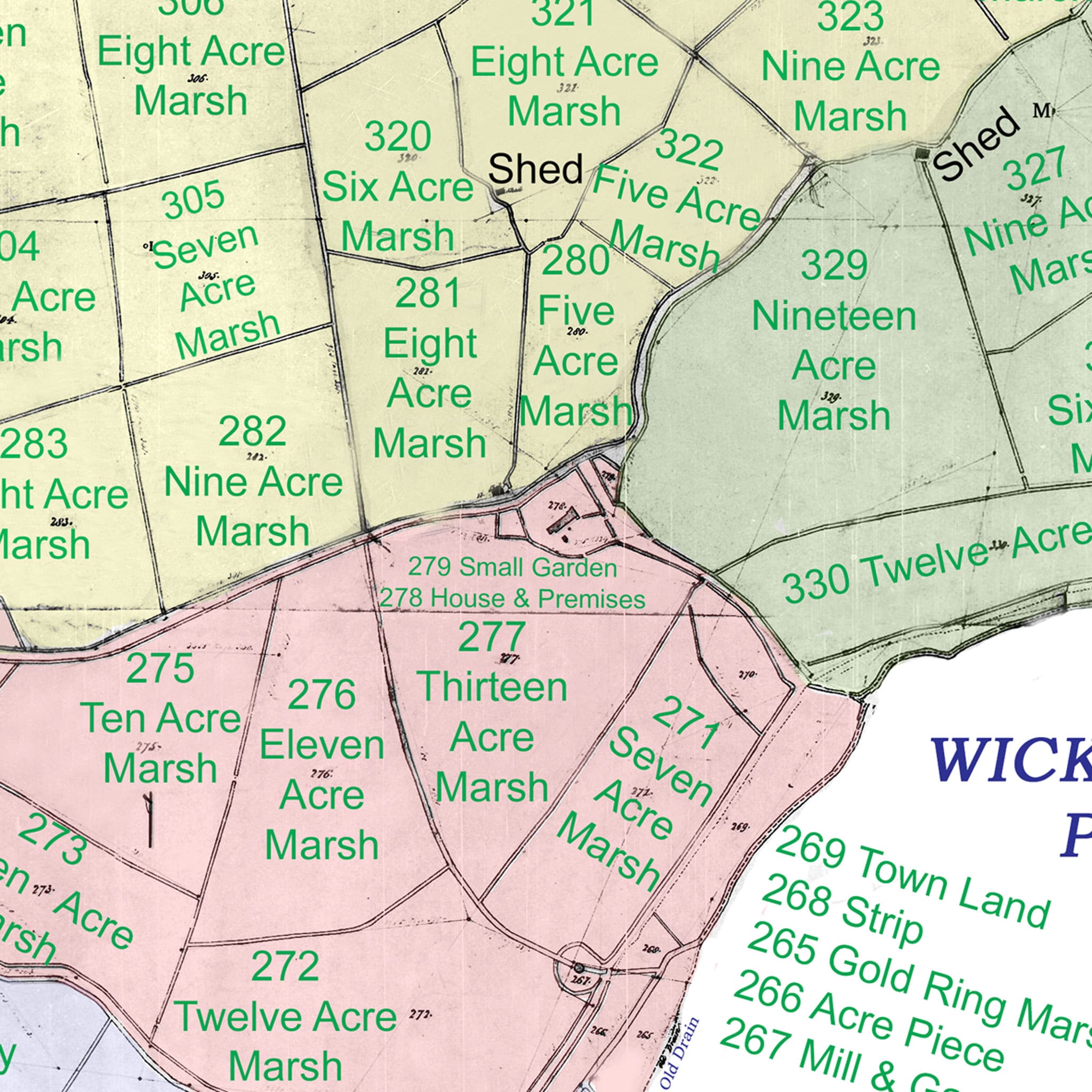
Jacky Heath has produced a rather splendid Tithe map. It shows Manor Farm House as a "House & Premises". There are also details of the apportionments.
 The full tithe map that Jacky Heath kindly sent me is a massive 54Mb so I have only reproduced an extract of the relevant portion.
The house is shown as marked as number 278 and described as "Frothelmes Level, House & Premises" a pasture of acreage 1.0.19 Owned by Robert Fellows Esq and occupied by John Howard, The area that is now Robin Wood is marked as number 279 and described as "Frothelmes Level, Small Garden" and also noted as a pasture with a much smaller acreage of 0.0.22. That small garden is also owned by Robert Fellows Esq and occupied by John Howard.
Robert Fellows Esquire is possibly the MP FELLOWES, Robert (1742-1829), of Shotesham Park, Norf. described in the History of Parliament, A fascinating read. He was the son of the 'Man of Shotesham' the philanthropic founder of the Norfolk and Norwich hospital. His nickname was Bob-of-both-sides! The Fellows were a notable family and MyHeritage.com also has information about them. I am sure that many a happy hour could be spent researching him.
in 1849 a Robert Fellows, Esq is shown as being a President of the Norwich and Norfolk Horticultural Society - probably a descendent of Robert Fellows Esq
On the Tithe Apportionments Robert Fellows Esq is shown as owning 26 parcels of land in Frothelmes and Scardell levels - he also owned what is now known as Mutton's Mill (parcel 267, described as Mill & Garden) which was occupied by John Howard.
The Acreage in A.R.P is probably Acres, Roods, and Perches. Rood is an English unit of area equal to one quarter of an acre or 10,890 square feet, exactly 1,011.7 m2. A rectangle that is one furlong (i.e., 10 chains, or 40 rods) in length and one rod in width is one rood in area, as is any space comprising 40 perches (a perch being one square rod). So the premises (278) is 4,527.4 SqM (1.12 Acres) and Robin Wood (279) is 556.5 SqM (0.138 acres). So the property as a whole is 2,084 SqM (1.26 acres)
The Tithe Apportionments are fascinating, some of the apportionments owners / occupiers family names are still resident in Halvergate— Hewitt, Mallett.
| GIS REF | Owner | Occupier | No. | Name and description | Cultivation | Acreage [A R P ] |
| HAL_ 278 | Fellowes Robert Esq. | John Howard | 278 | Frothelmes Level, House & Premises | Pasture | 1.0.19 |
| HAL_ 279 | Fellowes Robert Esq. | John Howard | 279 | Frothelmes Level. Small Garden | Pasture | 0.0.22 |
The full A1 PDF of the redrawn tithe map (compressed to just over 1MB for the original 54MB) and the associated apportionments is fascinating..